

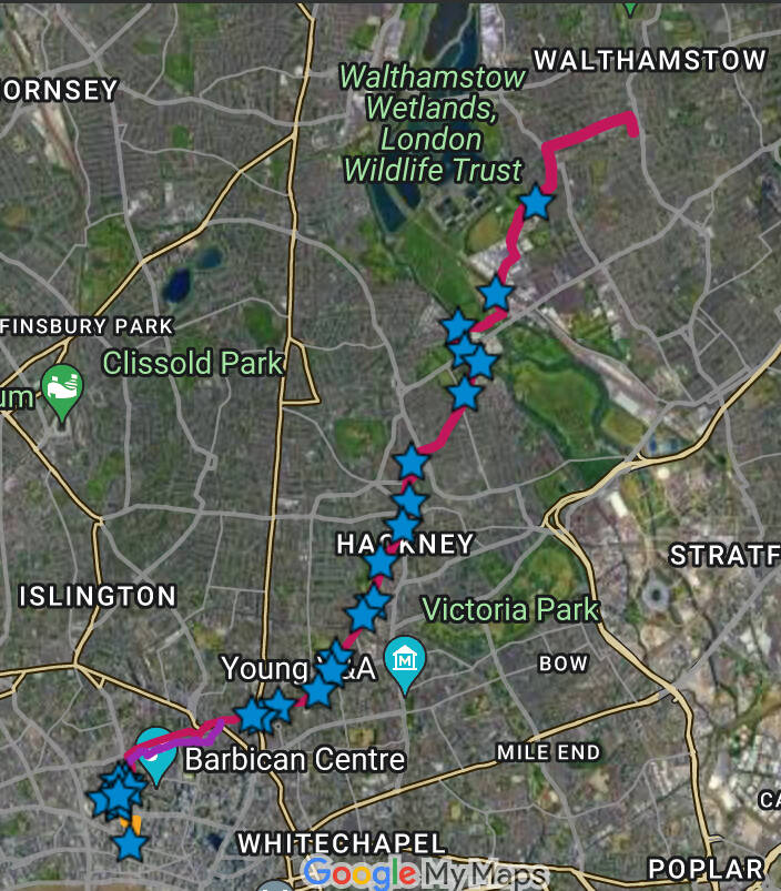
9. From VICTORIA PARK and VILLAGE to HOMERTON and HACKNEY
Content

You are now about to read the Second Part of the chapter
A reminder of the First Part landmarks:
—VICTORIA PARK VILLAGE. Shops and Eateries. Victorian. FRENCH (HUGUENOT) HOSPITAL. KNIGHTS HOSPITALERS
—HOMERTON WELL STREET MARKET. Shops and eateries
The FIRST Mr.COhen’ stall (a future TesCO!)
Second Part
—HACKNEY TOWN CENTRE
Hackney Designer hub: Shopping
SUTTON HOUSE SUTTON PLACE ST.JOHN’s Church, churchyard and a very important morgue MARE STREET: Hackney Empire, Town Hall, Local museum. Shops and eateries
—LOWER CLAPTON
—CLAPTON PARK. Victorian neighbourhood CHATSWORTH ROAD MARKET. Shops and eateries Banks of the LEA NAVIGATION
Welcome to HACKNEY!

CHATHAM PLACE — MORNING LANE OUTLETS Luxury Shopping, in HACKNEY?

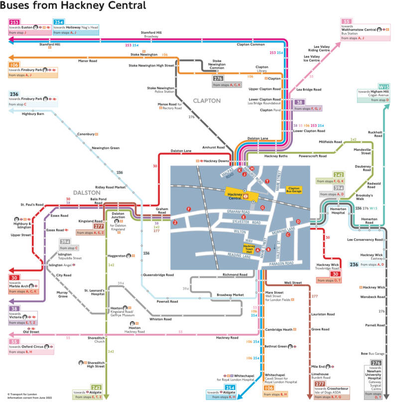
To the EAST of HACKNEY CENTRAL:
Buses alongside MORNING LANE (outlets) and HOMERTON HIGH STREET (Sutton House)
HACKNEY, an inner city district. Working class. Rundown Council Estates. Neglected streets, squares and gardens. Criminality. Riots (2011).
Well, all that is (almost)history. The area has been greatly regenerated, with the help of the money injected by various institutions, following the riots.
In fact, BURBERRY had established the first outlet, in the 90s, in the site of one of its factoríes, closed in 1991.
Definitely you are still off the beaten track, in (still) the less hipster side of Hackney. But think that if you had come to this area a few decades ago you would have found a barren place!.
Now, AQUACUTUM, PRINGLE, ANYA HINDMARSH, JOSEPH, NICOLE FARHI, COLOMBO, ZADIG & VOLTAIRE, MATCHES, NIKE… have taken advantage of lower property costs.
HACKNEY WALK (2016) was designed bybDAVID ADJAYE, for MANHATTAN LOFT CORPORATION.
THE BOX (2017) offers 3.000 sq.ft. of space devoted to sample sales.
HACKNEY EMPORIUM
New small business had as well the guts to open here, like RAILROAD CAFE, BREW FOR TWO (by EYLEM BINBOGA, fashion graduate by the RCART), BAR KINO…
Enjoy the initiatives of young local creative business people!
RAM PLACE
The GRAVEL PIT CHAPEL
Now AQUASCUTUM
RICHARD PRICE and JOSEPH PRIESTLEY were preachers here.
PRIESTLEY invented the carbonated water. He is honoured with a statue in BLOOMSBURY, at the ROYAL INSTITUTE OF CHEMISTRY.
First, this Non-Conformist temple became UNITARIAN. Later on, it was taken over by the CONGREGATIONALISTS.

Alongside Churchwell Path and Mehetabel Road
MEHETABEL is a Biblical name. In a land of Non-Confirmists, where the Bible is paramount, even the street-names reflect their religious world.
HOMERTON HIGH STREET
SUTTON HOUSE
Now, nicely restored, is owned by the NT.
A rare example of a TUDOR red brick house, in EAST LONDON. In fact, it was called BRYCK HOUSE!. And it’s the oldest house in East London!
B. c.1535 by RALPH SADLER, the Principal Secretary of State for HENRY VIII.
It became the dwelling of a succession of merchants and sea captains, a Huguenot weaver, a Victorian School mistress, an Edwardian clergyman….
In fact it has housed a boys school, and a girls school, and the ST.JOHN’S CHURCH INSTITUTE, or parish school. It became a CENTRE FOR FIRE WARDENS during WW2, and in the 60s it was rented by the ASTMS trade union.
Just think, though, that 50 years ago, this beautiful attraction was just one of Hackney’s numerous squats. In the 80s it was called the BLUE HOUSE, and was used as a music venue and social centre.
After eviction and a period of abandonment and disrepair , it has painstakingly restored to a state that does justice to its status!.
First, it was rescued by the SUTTON HOUSE SOCIETY (Save Sutton House campaign), who open it for the first time to the public.
The first works were completed in 1991. An art gallery was established, and as well schools and community programmes. Then it was licensed to hold marriages. A café opened. Now, exhibitions, concerts and lectures are held in the WENLOCK BARN.
Great job by the NT. And the MURAL left by the SQUATTERS in 1986 has been preserved…
Original, and rare, linen fold panelling (wood imitating folded linen or window tracery) , a Renaissance style carved stone fireplace, a Tudor window… plus 17th and 18th cs, additions, including the painted staircase, with crests of arms. A trompe-l’oeil on the frieze.
If I is true that the core of the house is original, in GEORGIAN times it suffered a number of reforms. For example it was enlarged, a storey was added, changing the type of roof, and eliminating the gables. Or sash windows instead of the mullioned ones, or a second entrance door, on the West wing.
So… what about Mr.SUTTON?.
THOMAS SUTTON, another notable of Hackney lived next door, in TAN HOUSE, which was demolished in 1806 (SUTTON PLACE was extended on its site). The name, thus, was a mis-attribution..
SUTTON PLACE
Admire the beautiful 1820s villas on the N side, and, on the S, a Georgian TERRACE, b. 1790~1806.
The street follows the course of a path through CHURCH FIELD
When in construction, lead was stolen from the roof of one of the houses, and the perpetrator, after being publicly whipped in the Village, was sent to the HOUSE OF CORRECTION, for un year.
The S side was built by CHARTERHOUSE, surveyed by WILLIAM PILKINGTON, who leased to WILLIAM COLLINS. And it occupied the site of medieval TAN HOUSE, which was used as a school.
The terrace is “soot washed”, a technique whereby the entire front was given a coat of soot, before fine white lining was applied to the darkened mortar, between bricks, giving an appearance of a finer brickwork.
Nos 1 and 2 are earlier and finer, with “barrel” bricks, wrought iron railings, and light wells. They were dwellings of wealthy merchants and gentry. A Mayor of Hackney and FERDINAND FREILIGRATH, exiled German poet lived here.
As many as 3 servants would life in the house, working in the basements, hauling coal from the cellars to the grates in the upper house. They had sitting and even sleeping quarters, and the kitchen. A range of small sheds at the rear is where washing was carried out.
The long gardens lead to the NIGHTSOIL PATH, used to collect and remove, by cart, the waste of the houses.
In 1847 the HACKNEY BROOK was culverted, becoming part of the incipient sewerage system. It is reputed to run in a large cast iron pipe through the rear gardens. The tube turns down ISABELLA RD, and joins the main network at OLD FORD.
In the 1830s, on the N, adjacent to the CHURCHYARD, the HACKNEY PRPRIETARY SCHOOL provided education for 130 boys. The MADRAS SYSTEM was used, whereby older pupils were appointed monitors, taking responsibility for the younger ones.
The school became controversial b3cause it employed many Non-Conformist teachers, and for its notorious ban on the sons of shopkeepers. By 1840, it went into decline and was amalgamated with the C of E GRAMMAR SCHOOL (on the site where the PEMBURY ESTATE is now.
The building became a private dwelling (SUTTON LODGE) until it was demolished in 1950, allowing the extension of the METAL BOX factory.
The 1820 villas to the N are accompanied by two blocks of flats, in keeping with the older buildings.
The street remained in the ownership of CHARTRRHOUSE, until well into the 20th c. METAL BOX purchased it, developing the factory and builfpding an office block. Now the core of the factory has become a private residential development, SUTTON SQUARE
At the end of the terrace 2 yards served as stables and garages. The one adjacent to SUTTON HOUSE, became a car breakers and repair garage (TAIKO AUTOS). The NT acquired it and BREAKER’S YARD was open to visitors as a garden, incorporating features commemorating its former use.
Later on one house was leased to MABYS METROPOLITAN INSTITUTION FOR BEFRIENDING YOUNG SERVANTS. It used to offer training and helped young girls from falling prey of a life prostitution.
Most of the houses fell into multiple occupancy. However, thanks to being listed (for historical reasons), they were saved.
From the 70s the area began to be gentrified, and the owners have endeavoured to restore their houses
Among the recent notable residents here, COLIN FIRTH
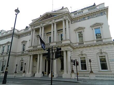
ST.JOHN AT HACKNEY, PARISH CHURCH
Magnus opus of Arch.JAMES SPILLER, friend of and very much influenced by SIR JOHN SIANE. Consecr. 1797. In order to improve acoustics he persuaded the trustees to reduce the capacity of the original project (by WILLIAM BLACKBURN) to 2.000 people.
Hackney was a huge parish (13 sq.kms, the largest of all that joined the COUNTY OF LONDON) and had growth immensely in population. The demand was therefore huge, and the old church could not cope.
Finally the body of the medieval church was knocked off, several tombs were removed to the new, bur the tower remained in place, holding the bells, as there were not enough funds to build a tower for the new church (until 1814).
In 1816 a new stained glass window behind the altar.
In the first decades of the 20th c. repairs, renovations and alterations. Electric lights. The roof, first shored up with scaffolding, was reconstructed.
Further reconstruction took place in 1955. But that year a fire started in the roof among the workmen’s tools, destroying the roof, the pews and the 1799 GEORGE PIKE organ.
A new reconstruction took place, with a reordering of the space: the HURDMAN HALL was created by inserting a partition.
The ALL SAINTS ENNISMORE GARDENS Church manual MANDER organ was installed.
Some hangings which were destined for WESTMINSTER ABBEY (for the CORONATION of QEII) were afterwards donated to ST.JOHN’s.
A new EAST WINDOW by CHRISTOPHER WEBB.
The reconsagration took place on the 24 th June, the saint’s day.
Again, in 2018 started a multi-million pound restoration project. JOHN PAWSON, a minimalist arch. who had designed the LONDON FASHION & TEXTILE MUSEUM, BERMONDSEY STREET, and ES DEVLIN, a visual artist, stage designer (stage sets for ADELE, BEYONCÉ, U2… 2012 Closing Ceremony, RIO DE JANEIRO 2016 OOGG Op. and Closing Ceremonies), reconfigured the church to an original GREEK CROSS, freeing more space for cult and music events.
The church has a working partnership with HACKNEY CH. BREW CO, whose profits help to fund work with homeless and vulnerable people.
It has become a notable music venue, with the likes of COLDPLAY, ROBBIE WILLIAMS and ED SHEERAN playing here.
And, in partnership with ST.LUKE’s HOMERTON TERRACE, HACKNEY CHURCH was formed, being designated a CIRY CENTRE RESOURCE CHURCH.
One of the trustees oversaw the subscription for planting the churchyard, HARRY SEDWICK. 129 subscribers provided enough funds to enable the plantation of avenues of elms and horse chestnuts. The SEDWICK’s TOMB commemorates his planting achievements. His son was lost in the NAPOLEONIC WARS, and is commemorated inside the church.
The MORTUARY. OPERATION MINCEMEAT
In a homely style, double fronted. A arched entrance for the hearse. Gable dormer windows B.1891. Arch THORTON GREEN. Includes rooms for a CORONER COURT.
Not a landmark of London. Nobody comes to see a mortuary… Why Should they?
MINCEMEAT?. A WORLD WAR 2 OPERSTION. A brainchild of IAN FLEMING according to some. In order to deceive Nazi Germany about the whereabouts of the landings in Europe, in 1942.
In charge of painstakingly creating a a back credible story, 2 MI5 officers: CHARLES CHOLMONDLEY and EWEN MONTAGUE.
A suitable body had to be found. A body of a vagrant who had commited suicide was laying in ST.PANCRAS HOSPITAL. MI5 got hold of him and brought it HERE, where it he lay for 3 months on ice. Meanwhile, the security services had time to create a fictitious character, an “OFFICER”, “MAJOR WILLIAM MARTIN”, who had to be planted with a fake letter, fake documents and fake private parafernalia. It would be dropped out to sea off the Spanish coast… The most important was the “letter” that the “Major” carried in his bag: a military communication stating that an ALLIED INVASION of GREECE and SARDINIA would be carried out, from the North of Africa. Nazi Germany believed the content of the letter.
The invasion of Sicily opened the way for the Allies to occupy Italy… And the rest, as they said, is history,
The route takes you either Southwards, to MARE ST. and the civic centre of the village and that of the modern district or Northwards, towards CLAPTON PARK and the LEA VALLEY
Towards MARE STREET, the town commercial and civic centre
ST.AGUSTINE’s Church TOWER
That is the only remaining part of the 16th c. parish church, which had replaced the one founded by the KNIGHTS OF ST.JOHN, in the 13th c. In medieval times, the parish covered the whole area of the current LB.
The parapet and the diagonal buttresses have been restored. And the 16th c. turret-clock.
The for
The faced clock did not appear until 1872, thought, after an appeal was launched.
As a symbol of Hackney it appears in the coat of arms of the Borough, in the masthead of the HACKNEY GAZETTE and in, in the Great War, the badge of the 10th (Hackney) Battalion of the London Regimentt.
The pop. was growing in the 18th. Galleries added. VESTRY petitioned PARLIAMENT permission to rebuild in an adjacent site to the N. In 1798, the old church demolished, some of the memorials and graves were transferred to ST.JOHN’s. THOMAS SUTTON entrails amongst them.
Finally in 1894 the 8 bells were relocated.
The cornerstones to the E of the tower were preserved, and the tower itself was used as a mortuary and as tool store
From the 1980s it has been opened up for art exhibitions, and even the roof can be visited, after climbing the winding stairway.

ST.AGUSTINE , was bishop of Hippo, and his teachings were followed by the KNIGHTS OF ST.JOHN.
In 1660 the church was rededicated to ST.JOHN
THE OLD TOWN HALL
You are now in MARE STREET, core of the old parish. The old commercial and civic centre.
Built in 1802, to provide a meeting place for the VESTRY COMMITTEE, the authority. Vestrymen were elected by wards.
In England, parishes, in fact, provided a framework for both civil (administrative) and ecclesiastical functions. During the 19th c. as population was growing, ecclesiastical parishes were subdivided (churches were built) to better serve the needs of the pop.
Between 1855 and 1894, the HACKNEY DISTRICT BOARD OF WORKS, which administered as well STOKE NEWINGTON until separation in 1893, sat here, as well.
Bank, betting shop and pub have been the successive uses of the building from the 1970s.
If you decide to linger alongside a stretch of the village street looking MARE ST., Northwards, the most interesting buildings are
No.366
No.389
No.397
And, if you explore BRETT RD. you will find a first:
BRETT MANOR

Please, let that the nearest DOCKING STATIONS ARE in LONDON FIEDS and N. of VICTORIA PARK
LO HACKNEY CENTRAL. MILDMAY LINE

Alongside MARE STREET, Southwards
See, in AMHURST ROAD, next to the entrance to the LO HACKNEY CENTRAL Sta
Site of E.GIBBONS, FURNITURE STORE
SYLVESTER HOUSE
THE OLD SHIP PH
THE HACKNEY EMPIRE THEATRE
Designed by the most famous Victorian theatre arch. FRANK MATCHAM, it opened in 1901, as a MUSIC HALL, later a VARIETY theatre. The ROCOCO auditorium, and reputed for its fine acoustics, is a spectacle of red and gold, splendorous. Gothic masks, golden cherubs…a spectacle of red and gold. Variety means Flamenco dancing, fire eating, Opera, comical sketches… in the same show.
CHAPLIN, WC FIELDS, LITTLE TICH, MARIE LLOYD, LOUIS AMSTRONG…
With the advent of cinema and television it went into decline. It hosted TV programmes, and even became a bingo for 25 y.
A grup of artists and local people formed SAVING HACKNEY EMPIRE, a group that fought with determination,to save it, and the area’s theatre culture.
Home to NEW VARIETY, a modern take on cabaret and comedy, it has acted as a forum for young talent (JULIAN CLARY, HARRY ENFIELD)
HACKNEY TOWN HALL

A frequent and very popular entertainer here, MARIE LLOYD, had been born in HOXTON (SHEPHARDESS WALK) and lived at 59 GRAHAM ROAD, DALSTON. In CHART ST. a PH was named after her..
The EMPIRE was his local theatre!.
THE LONDON BOROUGH OF HACKNEY, from medieval village to becoming“the University of feminine arts” then and London working class borough and ending up being touristic destination
The current LONDON BOROUGH OF HACKNEY stretches from the, I would say, thoroughly EAST END districts of HOXTON, HAGGERSTON and DALSTON, in the S. to the N. London suburbs of STOKE NEWINGTON and STANFORD HILL.
Now, you are in the centre, where OLD VILLAGE that gives name to the BOROUGH: HACKNEY. In a sense this was already the core of the area, as the main church, the only parish in medieval times was ST. AGUSTINE-ST.JOHN.
Mostly working class, since the INDUSTRIAL REVOLUTION, is no wonder that you find in the borough a huge ethnic diversity: the largest AFRO-CARIBBEAN community, after BRIXTON, a sizeable population ORTHODOX JEWISH, and even a greater number of TURKISH and KURDISH people. Without forgetting the small community of VIETNAMESE and LAOSIANS.
Only a 36% of the population is WHITE BRITISH. A further 18% is Irish and European. 7% are from Indian Subcontinent.
And no wonder that the MP who represents the district is LABOUR. For long years, the FIRST BLACK IN PARLIAMENT, represented the CONSTITUENCY : DIANNE ABBOT. And the COUNCIL was in the hands of the LOONY LEFT, following the terminology used by the THATCHERITE press.
The truth is that, to the West of Hackney, lied traditionally more affluent and genteel area
From Tudor times, around the quiet country villages to the North, rich merchants of London had built their second residences, far away of hullabaloo of the City. King HENRY VIII had as well a dwelling here (keeping in mind that some lands belonging to the KNIGHTS OF ST.JOHN became CROWN property after the DISSOLUTION).
In the 17th c. the locality had a reputation for having a few academic establishments, dedicated to girls (from those wealthy families, of course). Hackney received the accolade that you have incredously read on the title above.
SAMUEL PEPPYS, omnipresent and connoisseur, advised in his diary to come here, visit the church and… admire the girls!.
Some areas of the borough are marshy, and susceptible to flooding, as rivers have their course across the area, like the HACKNEY BROOK and the VALLEY of the RIVER LEA. The first has been culverted, the second is still important, but historically it separated tribes or nations (Catuvellani from Trinivantis, Middle-Saxons from East Saxons), then counties (MIDDLESEX - ESSEX) later on boroughs (HARINGEY, HACKNEY and TOWER HAMLETS - WALTHAM FOREST and NEWHAM).
Some parts of the LEA VALLEY became heavily industrialised, other were covered with reservoirs and water treatment plants. Now, you are going to find natural spaces, for you to enjoy.
However, the district was still industrial and working class in the last century, when the process of gentrification began.
By the way, right wingers laughted at the leftist Council when, in the 1990s, had the idea of appointing a “TOURIST OFFICER”, and sign posts started appearing since, pointing at “TOURIST ATTRACTIONS”. I bet the area is going to repay your visit. And right wingers were wrong.
MARE STREET. It must be about horses, must not it?
Yes, you are standing (or sitting down, in a café) in or near MARE STREET. And you come up with the idea that the origin of this street name is related to the female of the horse. Well, no… this was an OLD ENGLISH word for boundary (with the parish of STEPNEY). Or, it might be, the word MERE, meaning lake, pond, wetland… Now you know. But…
What about the name HACKNEY?. Old forms are HACKENEYE, HACQUENYE, HAKNEY, HAMENEYE.
That EY, EYE, with certainty, means island or an unaccessible area surrounded by water. HAKA’s island?. Remember, rivers and marshes are or were around. A in Saxon times a notable person of tribe would give their name to a place (WAPPING).
However, if the river had a bend (and the LEA has many of them), shaped a a HOOK -HACA- and island (EY) was on that bend (HACA)?.
Now, back to the horses. The HACKNEY HORSE was a breed developed in NORFOLK, in the 14th c. Curiously enough, that breeding intended to produce horses ideal for carriage driving, that is, with good stamina, arable of trotting at light speed and for extended periods of time.
I seems that sometime in history, HACKNEY supplied this bread of horses, and became famous for so. This means that the village name became the name of a type of horse, and not only in Englis!.
In Old French it became HAQUE, and from it, it passed to other langauges
In Old Spanish HACA, then JACA. A correct name is JACA NAVARRA.
In Sardinian .
In Catalan of Alguer, Sardinia (It. Alghero) is (H)ACA.
To recapitulate: the MARE ST. is not originated in anything related to a horse. But HACKNEY has originated the name of a type of horse, and in a few languages…
What if now we talk about the LONDON BLACK CABS, the famous taxis, oficially called HACKNEY CARRIAGE OFFICE?.
Some expert historians suggest that there is a link between carriages and horses. Remember that HACKNEY HORSES were bred for driving carriages. Problem solved.
However the American Hackney Horse Society favours an alternative etymology stemming from the French word haquenée—a horse of medium size recommended for lady riders—which was brought to England with the Norman Conquest and became fully assimilated into the English language by the start of the 14th century. The word became associated with an ambling horse, usually for hire.
Do Newyorkers call HACKS to taxis and taxi drivers. Or, do they say HACKSTAND, and HACKLINCENSE?.
Does BOSTON’ s POLICE DEPARTMENT, has a HACKNEY CARRIAGE UNIT, issuing HC MEDALLIONS?.
HACKNEY TOWN HALL
The site selected for current facility, the third town hall, was just to the west of the second town hall on land which had previously been occupied by residential properties.[6] The foundation stone was laid by the Minister of Health, Sir Hilton Young, on 22 October 1934.[7] It was designed by Lanchester and Lodge in the Art Deco style and officially opened by the Chairman of London County Council, Lord Snell, on 3 July 1937.[8] The design involved a symmetrical main frontage with thirteen bays facing onto Mare Street; the central section of five bays featured a doorway flanked by windows on either side on the ground floor; there were five round headed widows leading onto a balcony on the first floor with a clock and the borough coat of arms above.[1] The principal rooms were the council chamber, the mayor's parlour, the members' room and an assembly hall running along the rear of the building.[1]
The whole paragraph has been taken from the WIKIPEDIA
LEARNING CENTRE, PUBLIC LIBRARY & HACKNEY MUSEUM. And a café, a usual
In the library, sometimes, you might find interesting information leaflets, brochures or maps. Why not relaxing yourself a bit and read the papers… Or you can buy a used book on sale!.
The local museum explains the history and the present of the district in a way easy to understand, very visual. You will see it in less than an hour. At the desk, on sale, locally themed books.
The LB of HACKNEY COAT OF ARMS
ST. AGUSTINE’s TOWER, standing in a small green hill, in fact representing an ISLAND (remember the ethymology of the name Hackney, HACA’S ISLAND).
The MALTESE CROSS, representing the past owners of the Manor, TEMPLARS and HOSPITALLERS
The OAK TREES represent STOKE NEWINGTON. The red coloured acorns are visible
The blue bordure of the shield represents WAVES , that the rivers and canals
The 3 BELLS represent SHOREDITCH, more precisely the bells of ST.LRONARD’s Church, known for the nursery rhyme ORANGES AND LEMOS. The number of bells alludes to the 3 METROPOLITAN BOROUGH merged to form the current LONDON BOROUGH

HACKNEY PICTURE HOUSE
Originally Hackney Central Library and later a concert venue, this landmark building was converted into a cinema in 2011, creating some stunning interior spaces.
Picturehouse Cinemas and architects Panter Hudspith transformed the building into a six-screen venue with a restaurant and two bars. The Picturehouse touch has brought a mix of modern industrial glamour and urban cool to this Hackney Cinema, which is overtly bold and brutalist in construction. It's a fun, funky and impressive place to hang out. Citation from PICTURE HOUSES
Site of the WOMEN’S SOCIAL & RESCUE WORK FOR THE SALVATION ARMY HQ
VALETTA HOUSE (or BUILDINGS)
Valette Street was one of the earliest examples of publicly owned houses in Hackney. Built by the LCC in 1904 on the site of the former Jerusalem Square and Passage it housed skilled working class tenants and was built partly in respnse to an appeal by the Trades Council to relieve the high employment of building workers in the East End. Citation from Flickr
Shopping, eating and drinking
MARE STREET is lined with stores, supermarkets, shops, convenience stores, charity shops and eateries.
Remember the OLD SHIP PH?. What about the COCK TAVERN?. As usual, my favourite is a JD WETHERSPOON, BAXTER’S COURT.
The HACKNEY TAP, located in the old town hall
The CROWN PH is near the church, al the top end of village like MARE STREET.
You have PIZZA EXPRESS and the BRITANNIA, a greasy spoon.
PRET A MANGER and COSTA are in AMHURST RD.
Fancy staying here?
To the LEA VALLEY
Along LOWER CLAPTON ROAD
Former POLICE STATION
Housing offices, cells and accommodation this building was in operation until very recently. It was designed by arch. JOHN DIXON BUTLER for the MET, as so many other stations.
Slate mansard roof, with dormers. Attics and semi-basements. Attached buildings.
Door case, arched hood, console brackets on pedestal.
Three light-canted bay windows, narrow architraves windows with small lights above.
Stone-bracketed eaves cornice. Narrow lancet. Return wall gables form chimneys.
Chimney breasts, round arched recesses, stone keystones and vousoirs.
Recessed sashs.
Chimneys continue through apex of gables as separate.
Nos.14-16 GEORGIAN semi-detached pair, with semi-basement and raised GF. Third floor, added later, with mansard roof. Shallow dormer windows.
Stucco detailing. String course. Cornice to parapet.
The flat brick arches to windows are original, it now are covered in stucco, expressed as lintels.
No.14 has a repaired and altered projecting porch, circular corner columns. Iron balustrade and handrail.
No.16 had a 2 bay wide single storey extension built later, forming a shop unit, filling the front garden.
The STRAND BUILDINGS were originally the HACKNEY ELECTRICITY DEMONSTRATION HALLS and OFFICES
Art Deco, with a symmetrical PALLADIAN façade. A set back 3 bay arcaded main block, with a projecting GF shop front. Wings.
Heavy cornices at parapet height,
Façade clad in PORTLAND stone ash lar , or pre-cast corner.
The stylised details are DECO: Russification, ornamental pilasters, support brackets.
Above cornice, the parapet containing the name.
Steel windows
KING’S HALL & PUBLIC BATHS, now LEISURE CENTRE
- 1894-97. Arch. EDWARD HARNOR, with FREDERICKPINCHES
Portland stone, in a RENNAISSANCE style, with Ionic doorcases.The front was the administration block. The central spine housed the changing rooms. The main areas were either side of the pool to the left, now a sports hall, and the main pool is to the right.
The upper floor housed accommodation, served by a separate entrance.
Site of PH. THE ELEPHANT’S HEAD, became THE FITZGERALD
Late Victorian. Red brick, moulded brick string course and window details. Ornamental plaster panels. Plater pediment with an elephant’s head medallion. The GF front is original, and the interior conserves original features
Nos.19-35 The front gardens of the houses, subsequently built over to form shops, when the area was becoming a shopping district, in Victoria’s times. Good surviving parapet to roof line
CLAPTON SQUARE
A green space where used to be fields of the MANOR of the TYSSEN family, in fact the second largest garden square in the borough.
Around the garden 2 sides of terraces of Georgian houses, tall, partly stone-dressed. They were the homes of senior merchants, officers, financial brokers… pretty upmarket!.
5 storeys, with leaded fan lights, pilasters, upper cornices (white ledge), porticoes, sash windows, ornamental cast iron balconies, columns and porches. Some frontages are adorned with trained ivy or wisteria.
In the late 19th. Some houses were replaced. And the RECTORY moved here in 2006. The East side had to be rebuilt after WW2.
The garden contains shrubs, trees, and historic stone ornaments. The DRINKING FOUNTAIN was erected in 1894, as a gift to the residents by HOWARD MORLEY.
Figures who have resided in the square are:
Jewish writer GRACE AGUILAR
THEODORE ROTHSTEIN who, in 1920, was ambassador to the UK, and later on had other positions. He had settled in the country since the 1890s. His friend LENIN visited here. He died in 1953. Son ANDREW became a prominent member of the CPGB.
In no.5, THOMAS BRIGGS, a chief clerk of ROSARTS CHRTIS BANK. On. The 9 July 1864 he became the first person murdered on a train, in Britain.
A diversion is possible from CLAPTON SQUARE towards STOKE NEWINGTON via HACKNEY DOWNS PARK
On the map BRIGHTON ROAD, before joining the route to STOKE NEWINGTON from DE BEAUVOIR and DALSTON-KINGSLAND
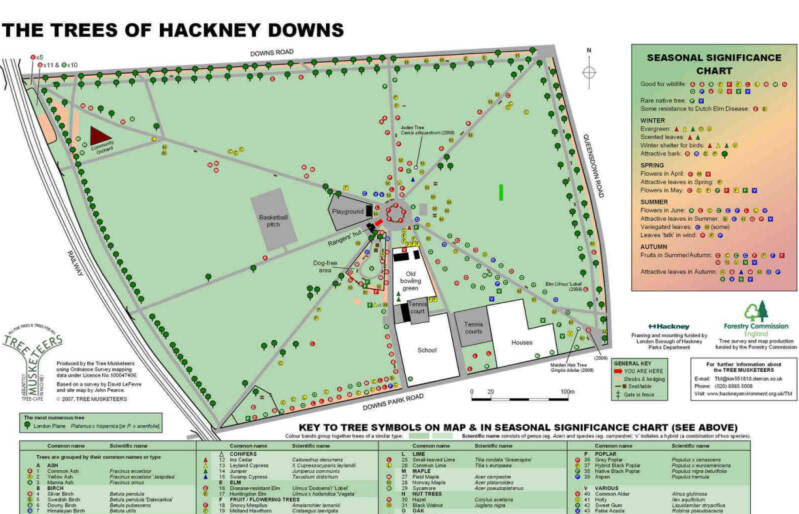
HACKNEY DOWNS
Off CLAPTON SQUARE: CLAPTON PASSAGE
HOLLY VILLAS
9 two storeys plus basement. The end building 3 storeys. In London stock brick, slate roof.
Ornamental stucco, arched windows with column and capital details.
In the GF, projecting segmental bays with lead roof.
Sharp-pitched gables at roof level. Brick quoin detailing.
No.22 is double fronted with vehicle entrance, arched GF. Some decorative ridge tiles remaining.
At the corner with the main road, you can read the plaque:
JOSEPH PRIESTLEY’s home.
Supporter of the FR1789, he had hounded by the mob out of his home and laboratory, in BIRMINGHAM. He was invited to come to HACKNEY to take up his post of Unitarian Minister at the OLD GRAVEL PIT CHAPEL, in CHATHAM PLACE (which in 1809 was transferred to PARADISE PLACE).
He had many friends amongst the Hackney Dissidents,
In 1794 he emigrated to AMERICA, fearing a repeat of his family’s persecution,.
To the rear of JP’s home, in a cottage, lived
LOUISA PERINA COURTAULD
She was a designer of gold plate, widow of a silversmith. They were HUGUENOTS. Their son was SAMUEL COURTAULD Jr, founder of the COURTAULD dynasty of silk and artificial fibre manufacturers; they made RAYON, artificial fibre made from natural sources. Another descendant, SAMUEL CURTAULD, as well, founded the INSTITUTE OF ART bearing that name.
Alongside the LOWER CLAPTON ROAD
ROUND CHAPEL
The ROUND CHAPEL
Opened here in 1871, but of more modest origins… In 1804, a Non-Conformist CONGREGATIONAL chapel was established at MORNING LANE, the OLD GRAVEL PIT CHAPEL, in fact a breakaway from the RAM’S CHAPEL, HOMERTON. From the 17th c. groupings and regroupings of Dissident churches were common in East London. This was a centre of the Non-Conformist movement, with s its cemeteries, academies, famous figures, like D. DEFOE and ISAAC WATTS…
The pop. had expanded: from 35.000 to 115.000, and then 230.000 in 1901. That needed an intense house building, with the creation of new suburbs (BRICKS and MORTAR!). CLAPTON PARK was born.
By 1868, the congregation of the OLD GRAVEL OIT had quadrupled, and they decided to build a new chapel: the CLAPTON PARK CHAPEL, which became one of the most important, growing in congregation volume and in the number of activities.
Amazing interior shape!. With cast iron columns, which created controversy, as, up to then, they were only used in railway stations and music hall theatres, being considered improper of a religious cult space.
From the last decade of the 19th c., the neighbourhood changed its composition and the congregation sunk.
Now, after years run down it is a Grade II* listed building (only four per cent of buildings are) and only the OLD SCHOOL ROOMS are kept by the UNITED REFORMED Church. It is managed as an arts and community venue.
You can long this Northwards route with the Southwards route from the UPPER CLAPTON area (CLAPTON COMMON, after STAMFORD HILL)
Alongside LOWER CLAPTON ROAD
MAITLAND PLACE.
Site of HOSPITAL FOR UNMARRIED MOTHERS
Semi-detached substantial villas b.c.1804, and used as nurses quarters and offices of the hospital f. by the SALV.AR. in 1884
At the rear, modern MOTHERS’ SQUARE lies on the site of buildings demolished in 1992. The new buildings were designed by arch. HUNT THOMPSON for the HOUSING ASSOCIATION, in a Classical style, delivering imitating Victorian Hackney. A central pergola reduces the effect of on-street parking. It earned the CIVIC TRUST AWARD.
Off LOWER CLAPTON RD., in LINSCOTT RD.
Site of the LONDON ORPHANS ASYLUM, now CLAPTON GIRLS ACADEMY.
B.1826, designed by arch. WS INMAN
A substantial Classic portico is the only remnants of the original building: in fact, the chapel and two colonnades that led to the dormitories.
The Asylum was vacated after the cholera epidemics of the 1860s, and the SALVATION ARMY took over, opening the building, in 1871, as the CONGRESS HALL. In 1937 it was used as a refugee centre housing 400 BASQUE children. According to BRIGADIER J MARTIN’s report, the kids were very undisciplined, the boys climbing over the roof “like little monkeys”. “For the most part they have no sense of religion or use for the church. They seem to have Communist sentiment”.
Nos.156-162. BISHOP’S WOOD ALMSHOUSES
The GAVILLER GARDEN
CLAPTON POND
HORTICULTURAL TRil. Click on this map to see the full leaflet in PDF

Said to be dug out during the early 1600s, by the HACKNEY WATER COMPANY, as a reservoir, for the purpose of domestic water supply and watering hole for livestock and horses.
By the 19th the pond laid out neglected, and finally plans were drawn up to drain it and fill it in. In 1898 the HACKNEY VESTRY purchased it and converted it into a public garden, landscaped with flower beds and new trees to a pattern that largely survives to the present day.
POND HOUSE
B. at the beginning of the 19th c., when CLAPTON had become a fashionable residential area, it constitutes a fine example of GEORGIAN architecture. In more modern times, it fell into neglect, an EH included it into its HERITAGE AT RISK REGISTER. At the beginning of our century, ONE HOUSING GROUP acquired it, and restored its features, like the bow window to the drawing room overlooking the gardens on the rear. In fact, the garden had been huge, when the house was built, with a wall of fruit trees, running for 640 feet, and including a melon garden, a seed house and a tool house. Two cows were kept to provide milk to the family. MAIDENWELL RD. occupies part of the garden now
Still alongside the LOWER CLAPTON ROAD
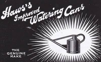
Site of an INVENTION!: J.HAWS WATERING CAN FACTORY
Our name comes from our founder John Haws, the inventor of the watering can design that we still produce, virtually unchanged to this day. Originally from Clapton in London, John was by his own account quite an unsuccessful gardener. But in 1884, while struggling to grow vanilla during his British colonial service in Mauritius, he set about designing his own watering can to improve his gardening fortunes.
In 1886 he secured the patent, established the Haws company, and described his unique design as follows: "This new invention forms a watering pot that is much easier to carry and tip, and at the same time being much cleaner, and more adapted for use than any other put before the public." The history of the company, copied up to here, continues…
Former CLAPTON CINEMATOGRAPH THEATRE
ST.JAMES’s Church
THISTLEWAIT ROAD
HAROLD PINTER
FIRST SYNAGOGUE in HACKNEY
Now, you are very close to the wide roundabout and to LEA BRIDGE ROAD. To the East, the LEA VALLEY. To the North, UPPER CLAPTON. The school between BROOKE RD. and KENNINGHALL RD. occupies the site of BROOKE HOUSE
Now, the route takes you to the West Bank of the RIVER LEA. The district is CLAPTON PARK
After CLAPTON SQ. and PASSAGE, alongside POWERSCROFT ROAD
Not this club. The UNITED SERVICE CLUB is in ST.JAMES’. The ver DUKE OF WELLINGTON, of WATERLOO fame, was a member, as many other high ranking officers of the British army in REGENCY times
No.69 Site of HACKNEY UNITED SERVICES CLUB LTD
B. in EDWARDIAN times as an association of ex-servicemen of WW1.
2 storeys + attic continued within the slated mansard roof. Tripartite window, stone mullions and surrounds.
Brick dentil cornice, painted string course.
Here, in 1925, says the Plaque “the old contemptibles Timon was born”, “to the Glory of God”, “to the imperishable memory of Captain French’s contemptible little army”.
It refers to the British FIRST EXPEDITIONARY FORCE sent to the WEST FRONT, in Aug. 1914. KAISER WILHELM of GERMANY was dismissive of the force and issued the note e stating: “exterminate the treacherous English and walk over General French’s little contemptible army”.
You are now in CLAPTON PARK
I suggest that you walk or cycle until you reach MILLFIELD ROAD, but toucan shortcut the route directly to CHATSWOR5H ROAD and enjoy a cup of coffee…
In 1749 was opened the HACKNEY CUT. To its East, a vast marshy wilderness, to its West an empty area. Land, for the most part, belonging to the the HACKNEY HOUSE ESTATE.
HACKNEY HOUSE was built, 1723-32, for STAMP BROOKBANK, MP and Governor of the BANK OF ENGLAND. The house itself was where the CLAPTON GIRLS ACADEMY no is, that is the site of the LONDON ORPHANS ASYLUM.
From the 1860s, the LONDON AND SUBURBAN LAND BUILDING COMPANY, built up the district, where hitherto market gardens and watercress beds were tended. And they came up with a name for the it. Not very original, but there you are.
First CHATSWORTH ROAD was laid out, on the site of a long field path, and the space in-between with LOWER CLAPTON RD. began to be filled vital streets of terraced houses. They had thought about everything: Shopping, entertainment (the CLAPTON PARK THEATRE, GLENARM RD.)), and… the TOWER BREWERY (ASHENDEN RD.).
By the 1880s a dense network of streets stretched all the way across to the HACKNEY CUT.
To the South, a remnant of the HACKNEY MARSH was still present: DAUBENEY FIELDS or GREEN.
Around the turn of the century the area South of REDWALD RD. was laid out.
Schools had to be build: RUSHMORE ROAD, DAUBENEY RD, MANDEVILLE ST. And CofE churches: ALL SAINTS and ALL SOULS (succeeded by the RISEN CHRIST & ALL SOULS).
In 1936-38 the LCC built the KINGSMEAD ESTATE, on a site previously occupied by the NATIONAL PROJECT SOCIEY and the KINGSMEAD SCHOOL. People moved here when they were displaced by slum clearances in BETHNAL GREEN.
The CP METHODIST Church was b. in 1958. RC ST.JUDE, in 1965, in BLURTON RD., on the site of 5he Methodist Chapel.
Victorian terraces were demolished, and the CHATSWORTH ESTATE built. The LCC’s BEVAN ESTATE included a 12 storey tower. The towers of the CLAPTON PARK ESTATE have been demolished, bar one.
LANDMARK HEIGHTS was built by private developers, on the site of the Council’s SUDBURY COURT.
The conditions of the KINGSMEAD deteriorated. “A blighted labyrinth, “where a paedophile ring operated, resulting in the abuse and murder of a teenager, “a council gardener holding satanic masses and murdered the 5 years old son of his girlfriend, “a police unable and/unwilling to curb the crime wave… That was CLAPTON PARK at the beginning of the 21rst c.
Now, the estate has improved, managed by SANCTUARY HOUSING, with the community support of HALL MARSH PARTNERSHIP.
And the terraced streets commenced a process of gentrification…
The 2012 OOGG played an important part in all this, a the process continues on, thanks to its legacy.
Now, enjoy that gentrification!. CHATSWORTH ROAD & BROOKSBY WALK
Pointed on the map, CHATS PLACE
HOMMERTON LO Station
This became the core of the Victorian district. Shops, eateries, and street market. Nothing has changed , you will think, let us go and enjoy… Bur now that you are here let me tell you that even myself I wonder sometimes how things change. II am telling you that 20 years ago. I would not have written this article. The state of things was quite different… but they were starting to change.
Enjoy the SUNDAY MARKET… if you are coming on a Sunday!. Otherwise, browse through the place, explore the shops and cafés, North to South, towards HOMERTON, where the street is, in fact, called BROOKSBY’S WALK
First, I leave you with that LADY IN LONDON who writes so well, with HACKNEY CITIZEN, about gentrification, and with the SLIGHTLY WEIRD blog, and then I will continue relating interesting places worth having a look, before you head North again, towards MILLFIELDS and then the LEE NAVIGATION.
THE CASTLE CINEMA. Art Deco
CHATS PLACE
You are now entering MILLFIELDS PARK SOUTH
MILLDFIELDS. LAMMAS LAND
Can you recognise the course of the BLACK PATH?
This used to be COMMON LAND with mills recorded on the banks of the LEA. Corn milling took place here in the Middle Ages.
The common rights were granted in 895 by KING ALFRED THE GREAT over all the marshes of the LEA. They were LAMMAS LAND, from the 12th of August to the 6th of April, each year. Resident farmer tenants were entitled to graze their cattle and horses. In the intervening period (April to August) hay was grown on strips of land belonging to the freeholders, which could be used to feed the animals in Winter.
In 1904 an Act of Parliament recognised this land as recreational, the development of which is restricted (METROPOLITAN OPEN LAND)
More about LAMMAS LAND. From Celtic calendar to ancient agricultural rights.
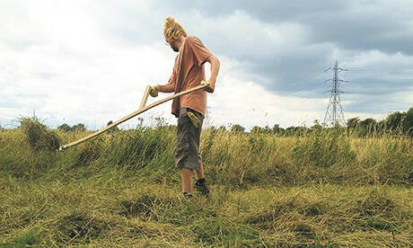
Photo from the HACKNEY CITIZEN. Enjoy the whole article.
The Celtic tradition divides the year into two seasons, winter, beginning at Samhain (pronounced ‘sal-wen’) on 31 October, and summer, starting at Imbolg (‘imulk’) on 1 February. Between the two, in the middle of the Celtic summer on 1 August, is Lammas Day.
Lammas signalled the shift of agricultural focus from plants to animals. It was the last day on which grass was cut for hay. Grazing could commence and the hunting season began. ‘The Glorious Twelfth’ – the first day for shooting grouse – is Lammas Day, pushed eleven days back by the UK’s transition from the Julian calendar to the Gregorian in 1752.
The right to cut hay and graze animals on certain fields extended to all parishioners, rich or poor. Such fields were known as Lammas land. Their use belonged to everyone.
Site of HACKNEY POWER STATION “A” & “B”. WASTE DESTRUCTOR
Hackney was a pioneering place when it comes to turn what’s te to power. Well we should be precise: SHOREDITCH has in fact that title (remember the CORONET STREET POWER STATION, of 1897). But, then SHOREDITCH was not part of HACKNEY.
Anyway, this was an era of vision, ambition and dreams, on the part of local authorities. Municipal dreams… especially in the fields where public health was involved.
This is the site of the A STATION, now totally demolished, was the most powerful combined refuse destructor and generating station yet erected (1901, arch. GORDON & GUNTON).
Instead the western wall of the TURBINE HALL and ancillary buildings of the B STATION still survive.
A wharf was leased to unload coal, and remove clinker. Thanks to the mounts of both, the CLAPTON ORIENT fans had a good, informal, SPION KOP. During WW1 this was, as well, a gun emplacement site.
Was that clinker used to surface local paths, and thence gave name to the BLACK PATH?
MILLFIELDS DISINFECTING STATION
B.1901-02. Listed Grade II. Arch.GORDON & GUNTON
The PUBLIC HEALTH COMMITTEE, under the auspices of CHIEF MEDICAL OFFICER J.KING NARMY MD, under the powers given to them by the LOCAL GOVERNMENT ACT 1899, had the initiative to isolate people whose houses and belongings had to be disinfected.
The power station next door provided the power for the steam cleaning operation.
You still can see the SHELTER HOUSE and the CARETAKER’S LODGE. Designed in ARTS & CRAFT, in re£ brick and stone dressings. TUDOR GOTHIC, in a cruciform plan. Mullioned windows. Stone Odilia de boeuf motif in gable end. The roof is modern, in concrete tile.
MANDEVILLE COMMUNITY PRIMARY SCHOOL
HISTORICAL RAILINGS
West side of NORTH MILLFIELDS
East Tennis courts SOUTH MILLFIELDS
BOUNDARY MARKER (1909)
Cast iron or steel posts with a rounded top. Cast or applied lettering: COUNTY OF LONDON, LC (for Lea Conservancy) BOUNDARY. Earlier one were of stone.
THE LEA BRIDGE CONSERVATION AREA
You are now in a former industrial district, as used to be all of the areas close to the RIVER LEA, until the middle of the 20th c. It is originally designated as a c.a. for its historical and architectural interest.
Beside a key route between London and the COUNTY OF ESSEX, and a key crossing.
A distinctive, secluded riverside hamlet, which housed like an “island community”, where “vile”, filthy trades erected the main mainstay, but where a school, a church, a pub have a place as well, together with the industries and the dwellings.
KING ALFRED had signed a Treaty with GUTHRUM (around 878) to limit the extent of VIKING lands. The Vikings had sailed up the river, from the THAMES, raiding HERTFORD in the late 9th c.
It is clear that the LEA RIVER, played the part of a natural boundary.
All around, a flood plain, which became recognised as common land.
The natural course of the LEA was an important transport infrastructure, but as centuries advanced that course needed to be straightened: the HACKNEY CUT or NAVIGATION, part of the LEE NAVIGATION Observe that, to distinguish both courses, a different spellingfor the river is used.
The LEA was important, during centuries, a a source of water and of power (watermills). But both activities were rather un incompatible, which originated friction between millers and bargemen in the M.A.

No. 47 Site of the CLAPTON FEDERATION SYNAGOGUE
Built in 1931 by M GLASS. This was demolished in 2006 and there are now flats on the site.
No.146 THE PRINCESS OF WALES PH
Said to be on a Roman site, apopular riverside pub in the 19th c. and was at one time called the PRINCE of Wales and contained many pictures of the Royal Family. It was rebuilt in 1920 with wood-panelled bars.
LEABRIDGE DOCK
Probably built before 1830 and called PARADISE Dock. It is also marked on some 19thmaps as ASHPITAL’S Dock. It was still in use pre-Second World War (an associated boatyard remained) but was filled in before the 1960s.
It has now been reinstated as a shallow water feature for new housing.
Site of the OTV BUILDING.
A 1960s concrete framed building that was built on stilts over the filled in Lea Bridge Dock and has now been demolished. OTV sold reconditioned video machines and black and white TVs
THE FERRY INN. This stood alongside the bridge on the Clapton site and was described as ‘ancient’ in 1757. It was later called the Horse and Groom and was demolished by the EAST LONDON WATER Co. around 1850
No. 142 Former CARBONIC ACID GAS factory
Behind a three-storey office is an engine house with a pediment roof and terracotta detailing. There is also a red-brick chimney and a yard paved with granite sets with traces of inset iron rails for trolleys. It was used by that Carbonic Acid Gas Company who made mineral waters or equipment associated with it. They attended the 1894 BEWERS’ EXHIBITION with ‘equipment for aerated waters’, but had however been in liquidation in 1893. The company was run by a RUDOLF STOKVIS, with input from Dutch interests.
S.SHAVEN, Furniture factory
At the back of the carbonic acid gas factory complex is a group of industrial buildings from 1935 used as a furniture works.
Boat builders with associated dressing rooms and club rooms 1902
Site of LEA BRIDGE RUBBER WIRKS. They made balloons, rubber toys and sports goods as well as sheeting and moulded products
No. 144 Former THE SHIP AGROUND PH
Late 19th. Stucco fronted with its roof hidden behind a parapet.
The LEA BRIDGE
Until 1757 the only bridges over the LEA were at BOW and WALTHAM ABBEY. All other crossings were made by the various ferrys then in existence. That year, by Act of Parliament, a timber bridge was built over the river, ana new TOLL road constructed, soon to be called LEA BRIDGE ROAD.
JEREMYS FERRY, which had existed at this point for years, was destroyed and no other ferry was permitted within half a mile of the new bridge.
By 1820, that first bridge was in poor condition, being replaced by an iron structure, sadly replaced again in 1897 by a more utilitarian bridge and better able to cope with the vastly increased demands made on it.